If you’re heading to Disney World soon, you need to keep a close eye on the weather reports.
A storm named Idalia is headed toward Florida and we’ve been sharing regular updates about Disney’s statements on the matter, what you should do if you’re planning a visit, and more. But now we’ve got an important update.
What once was Tropical Storm Idalia has officially become HURRICANE Idalia as of the latest updates on August 29th.
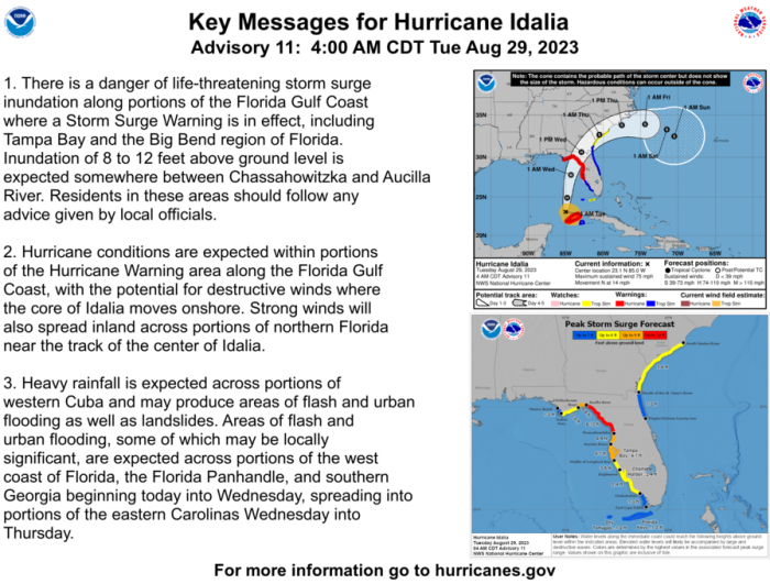
According to the 4AM CT updates from the National Hurricane Center, there is a continued danger of “life-threatening storm surge inundation along portions of the Florida Gulf Coast.” Strong winds are also expected to spread inland across parts of northern Florida.
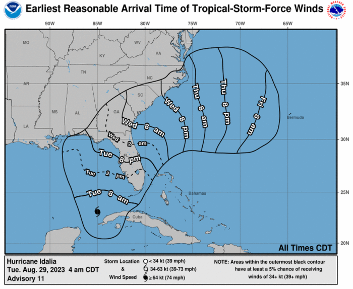
Here’s a look at the earliest expected arrival time of tropical storm-force winds. It looks like it’ll mainly hit parts of Florida by the afternoon/evening on Tuesday into Wednesday morning.
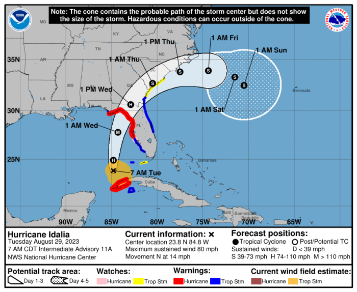
And here’s a look at the forecast cone for the center of the storm. It does look like it’s mainly expected to hit more northern parts of Florida.
According to the Orlando Sentinel, Hurricane Idalia is predicted to strengthen into a major Category 3 hurricane before it hits Florida’s Gulf Coast.
The Sentinel reports that NHC senior hurricane specialist Eric Blake has said “Rapid intensification is likely through landfall, and Idalia is forecast to become an extremely dangerous major hurricane before landfall on Wednesday.”
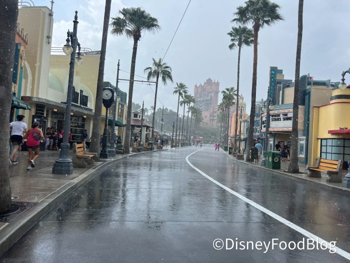
How will this all impact Central Florida? Well, Central Florida isn’t expected to bear the brunt of the storm, but it can still be affected.
According to the WESH 2 News weather alerts, a tropical storm WARNING has been issued for the 2 counties within which Disney World is located — Orange County and Osceola County. Previously, this was a tropical storm watch but it has been increased to a warning.
A tropical storm watch indicates that tropical storm conditions are possible within 48 hours, but a tropical storm warning indicates that tropical storm conditions are expected within 36 hours.
The tropical storm warning notes that Hurricane Idalia is expected to “cross the Florida Gulf coast on Wednesday as a major hurricane” and that preparations should be done this morning ahead of local tropical storm conditions that are expected by tonight into Wednesday.
They note that “Showers and squalls associated with outer rain bands from Idalia should reach central Florida later today, with conditions deteriorating further tonight and Wednesday.” They continue, “Based on the current forecast track, Idalia will make its closest pass to east-central Florida late tonight and early Wednesday morning.”
There is a threat of tornadoes that is forecasted to develop this afternoon as well.
According to the Orlando Sentinel, “The National Weather Service in Melbourne said parts of east Central Florida will see 2-3 inches of rain with some pockets hitting 4-5 inches, but also warning tornadoes could begin to form inland starting this afternoon with the threat continuing into Wednesday.” So strong winds and heavy rain are two things you should be be prepared for.
For more updates on Hurricane Idalia and tips on how to handle the situation, check out our posts below.
STORM UPDATES
Join the DFB Newsletter to Get All the Latest Disney News Delivered Right to Your Inbox! Click Here to Subscribe
Stay tuned for the latest news.
Join the DFB Newsletter to get all the breaking news right in your inbox! Click here to Subscribe!



 Our handy (and portable!) ebook guides make sure you get the best deals and can plan a vacation of a lifetime.

TRENDING NOW
You're not gonna want to hear this SAD update about a fun perk in Disney's...
We recently visited a popular hotel lounge to see if it still holds up!
Start your Disney World trip in THIS park. Trust us!
Soon, EPCOT will look totally different than it does right now!
Disney just dropped some MAJOR news and we're telling you all about it!
FREE DINING is coming BACK to Disney World, and we're sharing everything you need to...
Unfortunately, we've noticed one item has started disappearing from the parks and other Disney stores...
New Disney Crocs are online now!
The newest Disney Loungeflys are available now on Amazon!
These t-shirts are PERFECT for your next trip to Disney World -- and they're on...
Disney is rolling out some NEW discounts!
Along with Rialto's return also came some NEW snacks, so, of course, we had to...
A new permit that we spotted for another Magic Kingdom ride hints that maintenance of...
There is one trend that we've noticed at the Disney World parks that we wish...
There's been a major change in Disney World but we don't know if anyone will...
Disney adults who are Boomers will remember this one Disney World perk, but do you?
3 NEW stores are coming to the Downtown Disney District in Anaheim -- get the...
January is a WILD month in Disney World and you need to be prepared!
Disney just dropped some NEW ornaments online -- check them out here!
There are a few items that you're definitely going to want to bring with you,...